Friday, May 31, 2019 – Transiting south of Monterey Bay, CA
PUPCYCLE Log: Day 08 – Halftime at PUPCYCLE 2019
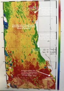
The 2nd half of PUPCYCLE 2019 started with a new game plan as the R/V Oceanus altered navigation and charted a new course, heading south toward Monterey Bay, California. Although the California Upwelling Zone (CUZ) covers the extent of California’s coastline, active upwelling events do not tend to be synchronous throughout the region. An area along the northern coast might be experiencing an active upwelling event while a region along the central coast might be experiencing a relaxation phase where upwelling has subsided temporarily. This is the situation occurring on the PUPCYCLE 2019 cruise. The researchers integrate several different data sets to determine the best location for each incubation site. In addition to taking continuous water samples from the Underway System and periodic launches of the CTD for water profiles (see Day 07: Thursday, May 30: The Bubble Lab), the scientists also download updated satellite images showing sea surface temperature and fluorescence. Sea surface temperature (SST) data identifies areas where upwelling is occurring by displaying cooler SST near the coastline and warmer SST offshore from the coastline, indicating the displacement of warmer surface water by colder water from depth. (Figure #18 – Satellite Imagery)
During this halftime break from deploying sampling equipment into the Pacific, the researchers are continuing to filter, prep, and store samples from Incubation Site #1 for phytoplankton-related measurements along with RNA sequencing after the cruise. The PUPCYCLE Log also continues in hopes that the information being shared here, and the supporting live feeds and images posted to the Science by the Sea® social media platform, provides you with a virtual experience of the 2-week cruise aboard the Research Vessel Oceanus. Today’s Challenge Question has been modified for our halftime intermission, so grab a bag of popcorn and check your current knowledge and understanding with this brief “Halftime Assessment”: